


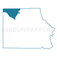
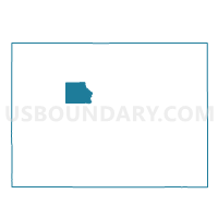
Eagle 10, Eagle County, Colorado
About
Outline

Summary
| Unique Area Identifier | 547749 |
| Name | Eagle 10 |
| County | Eagle County |
| State | Colorado |
| Area (square miles) | 98.88 |
| Land Area (square miles) | 98.48 |
| Water Area (square miles) | 0.40 |
| % of Land Area | 99.59 |
| % of Water Area | 0.41 |
| Latitude of the Internal Point | 39.86536280 |
| Longtitude of the Internal Point | -106.94992860 |
Maps

Graphs
Select a template below for downloading or customizing gragh for Eagle 10, Eagle County, Colorado


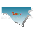
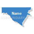

Neighbors
Neighoring Voting District (by Name) Neighboring Voting District on the Map
- Eagle 11, Eagle County, CO
- Eagle 16, Eagle County, CO
- Eagle 9, Eagle County, CO
- Garfield 11, Garfield County, CO
- Routt 10, Routt County, CO
Top 10 Neighboring County Subdivision (by Population) Neighboring County Subdivision on the Map
- Glenwood Springs CCD, Garfield County, CO (25,274)
- Eagle-Gypsum CCD, Eagle County, CO (18,567)
- Yampa CCD, Routt County, CO (799)
Top 10 Neighboring Unified School District (by Population) Neighboring Unified School District on the Map
Top 10 Neighboring State Legislative District Lower Chamber (by Population) Neighboring State Legislative District Lower Chamber on the Map
- State House District 61, CO (79,637)
- State House District 56, CO (79,238)
- State House District 57, CO (78,537)
Top 10 Neighboring State Legislative District Upper Chamber (by Population) Neighboring State Legislative District Upper Chamber on the Map
Top 10 Neighboring 111th Congressional District (by Population) Neighboring 111th Congressional District on the Map
Top 10 Neighboring Census Tract (by Population) Neighboring Census Tract on the Map
- Census Tract 9516, Garfield County, CO (3,912)
- Census Tract 8, Routt County, CO (1,951)
- Census Tract 1, Eagle County, CO (1,245)